Flood
Property
Weather
911 Address Search
911 Address Information
  • Address N/A
  • Latitude N/A
  • Longitude N/A
X

Select an address below to see the elevation information within an 50 foot radius of the 911 address point.

Layers
  • NOAA NEXRAD RADAR (latest image)
  • Current Warnings
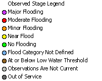
  • Observed River Stages
  • Significant River Flood Outlook
  • Snow Water Equivalent

Snow Water Equivalent

National Operational Hydrologic Remote Sensing Center. 2004. Snow Data Assimilation System (SNODAS) Data Products at NSIDC. Snow Water Equivalent. Boulder, Colorado USA: National Snow and Ice Data Center. doi: https://doi.org/10.7265/N5TB14TC
Regulatory
FIRM
Base Level
Engineering
BLE Flood Information
  • Latitude

    N/A
  • Longitude

    N/A
  • Elevation

    N/A
  • Datum

    N/A
  • Flood Zone

    N/A
  • County

    N/A
  • Political Area

    N/A
  • Effective Date

    N/A
BLE Water Surface Elevation
Flood Risk Comparison
  • 10% Annual Chance
    N/AN/A
  • 4% Annual Chance
    N/AN/A
  • 2% Annual Chance
    N/AN/A
  • 1% Annual Chance
    N/AN/A
  • 0.2% Annual Chance
    N/AN/A
Download Data
Print Map
FEMA Legend
X
Regulatory Flood Information
  • Latitude

    N/A
  • Longitude

    N/A
  • Elevation

    N/A
  • Datum

    N/A
  • Flood Zone

    N/A
  • County

    N/A
  • Political Area

    N/A
  • Community ID

    N/A
  • Panel Number

    N/A
  • FIRM Effective Date

    N/A
  • Jurisdictional Authority

    N/A
Water Surface Elevation
  • 1% Annual Chance N/A
0.2% Annual Chance Elevation:
85.4ft
Flood Depth:
2.5ft
Legend
  • floodway legend Floodway
  • 1% annual chance legend 1% Annual Chance
  • 0.2% annual chance legend 0.2% Annual Chance
Show Full FEMA Legend
Download Data
Print Map

Click on the projects below to see tiles that intersect your selection. Tiles that will be downloaded are highlighted in yellow. Projects not listed, have no tiles that intersect your selection.

Selection Tools

There are multiple ways to select the data to download. Make your selection using the options below. Once your selection is made, only the work areas highlighted will be downloaded.

Select work areas that intersect with a box you drag on the map.

Select work areas within a radius of a point clicked on the map.

Select work areas that intersect an existing feature that you select.

Point Selection

Click on the map where you want to center your search. You will then be prompted for the radius.

Box Selection

Click on the map and hold the mouse button down to outline a box.

Polygon Selection

Click on map to draw a polygon on the map. Once the polygon is drawn, click the Finish Selection button to search for work areas intersecting the polygon.

Feature Selection

Choose a feature from the list below to use to query the LiDAR availablity. Once selected, click the Select Feature button then click on the map to select the feature to use to query the LiDAR.

Select By

Selection Results
X

Below is a list of the Base Level Engineering Work Areas that intersect your selection.

Open ftp://ndramftp.swc.nd.gov with an ftp client to download the data.

The ftp credentials:

username:ble_user
password:swc_ble123

main map

Choose Radius
1 mile.
5 miles.
10 miles.
20 miles.
50 miles.
100 miles.

North Dakota Risk Assessment MapService
Download FIRM Data
X
Regulatory FIRM Data
X

Flood Insurance Rate Map (FIRM) - Official map of a community on which FEMA has delineated the Special Flood Hazard Areas (SFHAs), the Base Flood Elevations (BFEs) and the risk premium zones applicable to the community.

Data obtained from the FEMA National Flood Hazard Layer - https://www.fema.gov/national-flood-hazard-layer-nfhl

Layer Information
X

The NOAA NEXRAD RADAR layer is from the WMS service provided by the National Weather Service. More information can be found at https://www.weather.gov/gis/WebServices.

The Current Warnings layer is from the WMS service provided by the National Weather Service. More information can be found at https://www.weather.gov/gis/WebServices.

The warning text information is obtained using a point query on active alerts from the NWS API Web Service. More information is available at https://www.weather.gov/documentation/services-web-api.

The Observed River Stages is from the WMS service provided by the National Weather Service. More information can be found at https://www.weather.gov/gis/WebServices and https://idpgis.ncep.noaa.gov/arcgis/rest/services/NWS_Observations/ahps_riv_gauges/MapServer.

The Snow Water Equivalent data is from the National Operational Hydrologic Remote Sensing Center. 2004. Snow Data Assimilation System (SNODAS) Data Products at NSIDC. Snow Water Equivalent. Boulder, Colorado USA: National Snow and Ice Data Center. https://doi.org/10.7265/N5TB14TC

Base Level Engineering
X

The Base Level Engineering (BLE) data is a FEMA Non-Regulatory product that is meant to provide additional information beyond those products that appear on a FEMA Regulatory Flood Insurance Rate Map. The BLE production approach combines high-resolution ground elevation data, and modeling technology advancements to create engineering models and flood hazard data. These analyses are produced at a large scale as opposed to targeting individual stream reaches. The flood hazard information prepared is based off engineering models that determine base flood elevations, water depth, and water velocity along each stream reach studied.

BLE dataset was prepared in partnership with the North Dakota Department of Water Resources and FEMA Region VIII. Mapping products finalized June 2019.

Alert!! Please Read.
X
Disclaimer

Disclaimer

This data is provided by the ND Department of Water Resources for your convenience. This data is provisional. This service is provided "AS IS" and without warranty of any kind, either express or implied. No warranty, either expressed or implied, is made regarding the accuracy or utility of the data or information presented at this site. The ND Department of Water Resources is not responsible for any errors or damages that may occur resulting from the use or mis-use of the data that is provided at this site.

Laura Horner
Phone: (701) 328-2759
E-Mail: lmhorner@nd.gov

If you have any questions regarding the data, generation methods, or errors, please direct any comments to Laura Horner at the ND Department of Water Resources.

I have read the disclaimer and accept the data as is.